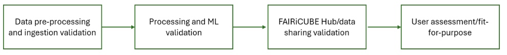
Validation of Data and Data Ingestion
The process of ingesting data is required for the effective use of any data resource under FAIRiCUBE. This process varies depending on the nature of the data involved. FAIRiCUBE-specific data undergoes a careful ingestion process into either rasdaman data cubes or EOX systems, depending on what they need.
Specific attention is paid to ensuring the FAIR principles (Findable, Accessible, Interoperable, and Reusable) throughout.
Ingestion validation (including data pre-processing) is an initial part of the User Case implementation.
| Process | Check type | Characteristic | Description |
|---|---|---|---|
| Data Validation for Ingestion | Data validation checks | Duplicates | Check for duplicate entries. |
| Date overlap | Check for overlaps in the date column, i.e., repeated dates with different values (only for timeseries). | ||
| Date gaps | Check for missing dates between start and end date (only for timeseries). | ||
| No data values | Verification of the correct use of no data. | ||
| Value types | Check if data types are correct (string, integer, float, datetime format). | ||
| Value encoding | Check if the encoding of the data is correct (e.g., character encoding is utf-8; point (.) is used as decimal separator). | ||
| Statistical Comparison of Characteristics with Source Dataset | Completeness | Calculate and evaluate the ratio of not-NULL values. | |
| Count of distinctive values | Count and evaluate the number of distinct values in the dataset. | ||
| Ratio of the most frequent value | Determine the number of occurrences for the most frequently repeated value, normalized by the batch size. | ||
| Maximum | Maximum value of the dataset | ||
| Mean | Mean value of the dataset | ||
| Minimum | Minimum value of the dataset | ||
| Standard deviation | Standard deviation of the dataset | ||
| Number of records | Number of rows in the dataset (e.g., number of polygons) | ||
| Date range | Start and end date (only for timeseries) | ||
| Spatial Characteristic Comparison with Source Dataset | Grid boundaries | Top-left and bottom-right coordinates (only for gridded datasets) | |
| Data completeness | Verify data set is complete (total area, total number of features or pixel) | ||
| Projection/CRS | Verify correct use of the projection/CRS. | ||
| Pixel size | Verify that the pixel size is correct | ||
| Number of bands | Verify all channels have been transmitted correctly. | ||
| Number of attributes | Verify all attributes of the table or vector dataset have been transmitted correctly. | ||
| Datatype | Check if the data type is OK. | ||
| Data format | Check if the ingested data follows the desired standard format (e.g., for raster, cloud optimized Geo Tiff) | ||
| Centre coordinates and total area | For vector data, check if centre coordinates of polygons match (to find shifted polygons or duplicate polygons) |